
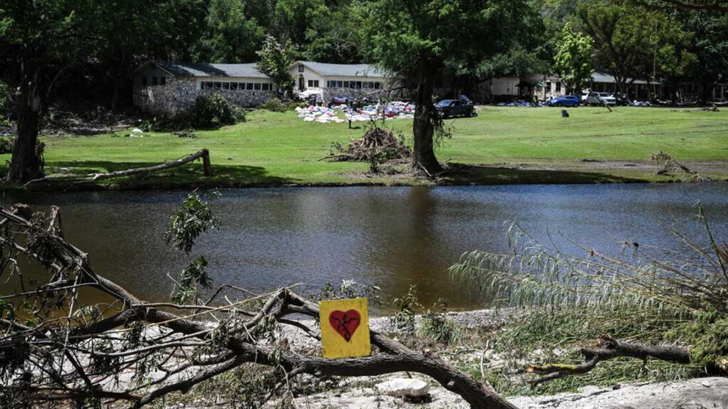
When torrential rain hit eastern Texas, turning the peaceful Mystic summer camp into a deadly trap within hours, few imagined that the tragedy—claiming over two dozen lives—was not just a natural disaster. It was a foreseeable catastrophe, hidden beneath layers of bureaucracy, outdated maps, and political apathy.
For years, maps issued by FEMA, the Federal Emergency Management Agency, have served as a kind of Bible for flood risk assessment. But they failed to account for one critical factor: the climate is changing, and with it, the nature of the threats we face. A new investigation by NPR, FRONTLINE, and data scientists from the First Street Foundation paints a starkly different picture—revealing that nearly twice as many structures at Mystic Camp were at risk than FEMA ever acknowledged.
Of particular concern is how FEMA’s underestimated flood zones have become a national pattern. The agency’s models rely heavily on coastal storms and major river flooding, often overlooking flash floods and intense rainfall that are becoming increasingly common due to climate change. According to First Street, more than twice as many Americans live in high-risk flood zones as FEMA’s maps indicate—leaving countless homeowners and even local officials unaware of the real dangers.
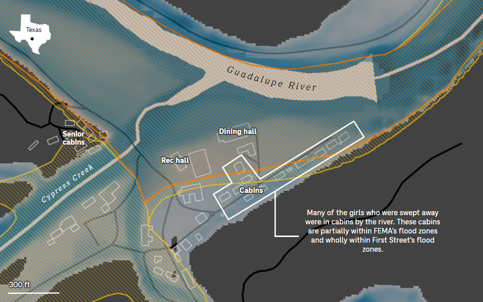
At Mystic Camp, at least four cabins—used by children—were located in FEMA-designated “extreme risk” zones, where floodwaters are expected to move fastest and reach the greatest depths. These were the very areas devastated when the floodwaters surged.

Outdated Maps, Avoidable Consequences
At first glance, this might seem like a technical oversight. But the deeper truth is far more troubling. Efforts to modernize FEMA’s flood maps have repeatedly been stymied by lobbying from homebuilder associations and politicians wary of increasing building costs. Updated maps would reveal greater risks, leading to stricter building codes and potentially pricier insurance premiums. For some, that’s a financial burden too inconvenient to accept.
Yet the cost of inaction is measured not in dollars, but in lives.
When Hurricane Helen struck western North Carolina last year, 98% of homes that flooded were located outside FEMA’s mapped flood zones. Those homeowners weren’t required to carry flood insurance and weren’t advised to build for flood resilience. The pattern echoes in Mystic and beyond.
A Camp on the Edge—A System on the Brink
Officials in Kerr County declined NPR’s request for interviews, citing an ongoing emergency. Records show that the county did pass two ordinances in 2020 aimed at tightening construction rules in high-risk flood zones. But those efforts weren’t backed by updated flood data. FEMA’s maps, it turns out, had gaping holes.
“No one should be in extreme-risk zones,” said Professor Jim Blackburn, co-director of the Severe Storm Prevention Center at Rice University. “These are the most dangerous of dangerous areas.”
At Mystic, the camp’s dining hall, recreation center, and four cabins sit just a few hundred feet from a sharp bend in the river—an area where, experts say, floodwaters accelerate dangerously during storms. Many of the camp’s buildings date back nearly a century, but FEMA often prohibits any new construction in these zones and enforces strict building codes for existing ones.
A Lesson No One Wants to Learn
The Mystic tragedy isn’t just about FEMA. It’s a broader story about how science, warnings, and obvious risks are routinely ignored when they become inconvenient. How immediate savings are prioritized over long-term safety. How federal agencies, local governments, and industry groups together perpetuate a dangerous illusion of security.
“We can’t keep calling these events rare,” Blackburn said. “They’re happening. The science is solid. We need smart, evidence-based decision-making—and right now, we don’t have that.”
Months after the flood, FEMA has yet to publicly respond to the inconsistencies uncovered in Mystic. Meanwhile, tens of thousands of schools, camps, and homes across the country may be sitting in similar danger—on the edge of an invisible threat drawn on an outdated map.